Danger lurks when states try to delineate complex borders that had never been envisaged as international frontiers.
Image: Ollyy/Shutterstock
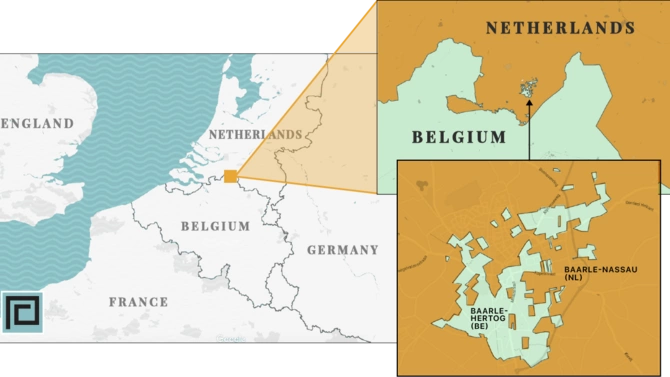
I love maps. So much information crammed into so little space. And so many questions begging to be asked. Try zooming in on a map of the Dutch-Belgian border between Breda and Turnhout, and you’ll find something mind-blowing: the Dutch town of Baarle-Nassau is intertwined with the cartographic shards of its Belgian twin called Baarle-Hertog. The latter forms dozens of mini-exclaves (political ‘islands’) within the Netherlands – and stranger still, there are at least six further Dutch patches within Belgian areas within the Netherlands. It’s the world’s craziest frontier, but, thankfully, as both countries are very close partners, the result is simply a minor tourist curiosity. The borders are marked with crosses or studs in the road, not with barbed wire and guards. You can even sit at the street café of Den Engel with one foot in either country.
But what if the Dutch and the Belgians were to fall out? What if the border were then erected? Such a nonsensical border could then prove a major geopolitical headache.

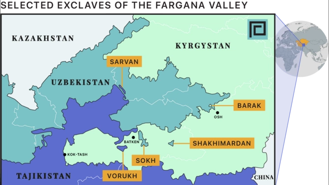
Something like that is precisely what happened in several places after the USSR broke apart in the early 1990s. One of the most glaring examples was in the Ferghana (Farghona) Valley. Nicknamed the ‘cockpit of Central Asia,’
the area is home to around 14 million people - nearly 20% of Central Asia’s population squeezed into less than 1% of its land area. In pre-Russian days, the valley had formed a single political unit under the Khans of Kokand. In the early Soviet period, it was partitioned - though, for decades, the borders that were drawn remained largely notional.
The main valley, containing several of the Fergana’s most significant cities, was assigned to Uzbekistan – forming a beak-like diamond of land caught in the cartographic ‘claw’ of western Kyrgyzstan. Jutting up from the south was a periscope of Tajikistan thrust into the southern flank of the valley, where it grabbed the historic city of Khujand. And for good measure, the map received a little extra spice from a sprinkling of exclaves: small cartographic ‘islands’ of territory surrounded by different states. For example, since 1955, Sokh has been a thin sliver of Uzbekistan forming a north-south slash within Kyrgyzstan’s Batken Province – strange enough as a piece of cartography, but odder still when you learn that its population is almost entirely ethnically Tajik.

The idea behind such cartographic craziness can be traced back to the USSR’s seemingly self-contradictory twin-pronged policy towards its outer republics. On the one hand, the concept of korenizatsiya (“indigenization”) pushed regions to develop a ‘national consciousness’ including a nurturing of local languages and culture. But at the same time, Soviet policies, both economic and bureaucratic, were aimed at tying republics together, whether by making factory supply chains mutually dependent or by creating convoluted borders that necessitated interaction. The message was clearly that any breakdown of cooperation between republics would be potentially painful. By the 1980s, after nearly 70 years as a functioning union, nobody imagined that such borders would ever have much real-world meaning. Then, with remarkable suddenness, the USSR collapsed, and those nominal borders became national frontiers.
The message was clearly that any breakdown of cooperation between republics would be potentially painful.
Suddenly the long looping ‘domestic’ railway line between Bishkek (Kyrgyzstan’s capital) and Osh (that country’s second city) had to cross international borders nine times on a single journey. And in the later 1990s, as Uzbekistan became increasingly isolationist, these borders hardened. Not surprisingly, the Bishkek-Osh train service stopped functioning. In Kyrgyzstan’s southwestern ‘claw,’ Sokh’s artificial isolation meant that it temporarily became a semi-anarchic no-go area in the late 1990s. Today the exclave remains a timewasting blockage for travellers on the main road between Osh and Batken.
Worst of all seems to be Vorukh – a Tajik exclave within Kyrgyzstan’s Fergana Valley area. Though reputedly very beautiful, the area has been the epicentre of many minor conflicts in recent years, most significantly in late April 2021, with over 30 dead in a wider-ranging series of disturbances. Though sparked by a seemingly innocuous disagreement over a water channel (further west at Kok-Tash), tensions had been high for several weeks following the suggestion of giving Vorukh to Kyrgyzstan in a Kyrgyzstan-Tajikistan land swap. The outwardly sensible idea was part of a recent drive to aid border simplification and demarcation, but it caused outrage amongst Tajiks, and Tajikistan’s president swiftly denied the rumours. However, many other Central Asian border problems have been mitigated through new roads, improved inter-state cooperation and various bilateral agreements, especially since the change of leadership in Uzbekistan following the 2016 death of Islam Karimov. And even the Fergana’s knottiest issues are now being carefully discussed.
In the Caucasus, the situation has many parallels. At independence in 1991, border demarcation was not fully agreed upon between any of the three states. In the case of the Armenia-Azerbaijan frontier, there was the added complication of a state of war followed by a long-frozen conflict. De facto lines of control that separated the nations at ceasefire would end up remaining reasonably stable for over two decades. More importantly, large parts of western Azerbaijan were occupied by Armenia from the early 1990s, and an internationally unrecognized “Nagorno Karabakh Republic” was formed. In reality, that entity was treated as a continuation of Armenia, which appeared to be confident that their territorial gains would become permanent. As a result, residents near the nominal Armenia-Azerbaijan border saw no reason to pay particular attention to where the official line had been.
The 2020 Second Karabakh War has changed all that. Suddenly, from November 2020, the demarcation of that border became both relevant and extremely urgent. In principle, you might think this would be easy: just look at the pre-1991 Soviet maps and Bob’s your uncle. However, the devil’s always in the detail.
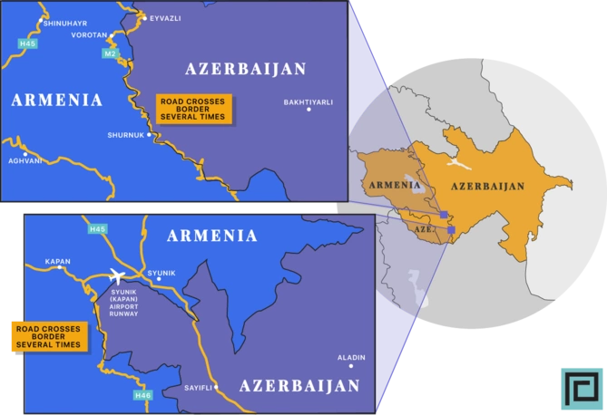
Try zooming in on the Qubadli/Syunik areas of Azerbaijan/Armenia, and you’ll see some fairly obvious problems. The best known of these is the village of Shurnukhu, a place that lies just within Armenia (though it had been home to ethnic Azerbaijanis until 1989 when they fled to other parts of Azerbaijan). The 1988 Soviet map shows the Armenia-Azerbaijan borderline cutting through the village along the main road. Since the 1990s, with the border essentially forgotten, Armenians who came to live in the village expanded the settlement with a dozen houses built on the ‘other’ side across the road.
Sadly, mistrust and lack of community groundwork meant that the Armenian residents of the 12 houses that would now fall within Azerbaijan were either unable or unwilling to legitimize their properties and instead vacated and burned them.
On 4th January 2021, however, true to the letter of the 2020 ceasefire, the northeastern part of the village was handed back to Azerbaijan. Sadly, mistrust and lack of community groundwork meant that the Armenian residents of the 12 houses that would now fall within Azerbaijan were either unable or unwilling to legitimize their properties and instead vacated and burned them. Press reports noted the sensitive balance between those bemoaning the division of the village with others hoping for an economic boost.

Shurnukh (Şurnuxu) is just the most obvious of several potential trouble spots along the primary Goris-Kapan-Meghri ‘highway’ – a slow, winding, but essential trade route between Yerevan and Iran. Several sections of that road zigzag across the border – at least technically. Most significantly, near Vorotan, the route winds 2km through the ruins of what was once the Azerbaijani village of Eyvazlı. Then there’s the fact that at the larger town of Kapan (known to Azerbaijanis as Kafan), the border comes within 100 metres of the recently rebuilt Syunik Airport runway. Worried Armenian citizens have protested in Kapan, voicing concerns about the new border demarcation.
These issues need sensitive handling. Winning peace depends on a certain degree of compromise to balance bureaucratic exactitude with realistic attempts to ensure that people’s livelihoods are enriched rather than compromised by cartographic solutions.
If border demarcation is going to stick religiously to the lines on the 1980s maps, there is another lurking problem waiting in the wings. As in Central Asia, the Soviet-era Caucasus had a handful of little one- or two-village exclaves: Kerki, Yukhari Askipara, and Barkhudarli/Sofulu [1] being blobs of Azerbaijani territory within Armenia, and Artsvashen being a disconnected chunk of Armenia within Azerbaijan. Since the First Karabakh War, these exclaves have ceased to exist in any meaningful sense. Their original populations fled, and the villages either remain abandoned or have been resettled by newcomers. From an outside perspective, it might seem an elegant idea to quietly accept the status quo and prevent the practical difficulties of dealing with extra exclaves. However, it would take considerable political courage to reformulate such an agreement given the obvious desires of many long-term IDPs to return to their villages of birth. And, as can be seen from Central Asia’s trouble-plagued examples like Vorukh and Sokh, re-instating such exclaves could be even more of a poisoned chalice than deciding to form an amicable and mutually beneficial solution.
[1] Yukhari Askipara, Barkhudarli and Sofulu are just three of seven villages in Azerbaijan’s Qazax Region which remain under Armenian occupation. The others (Ashagi Askipara, Qizil Hacili, Seyid Ayrim and Kheyrimli) are not in exclaves.
Share on social media