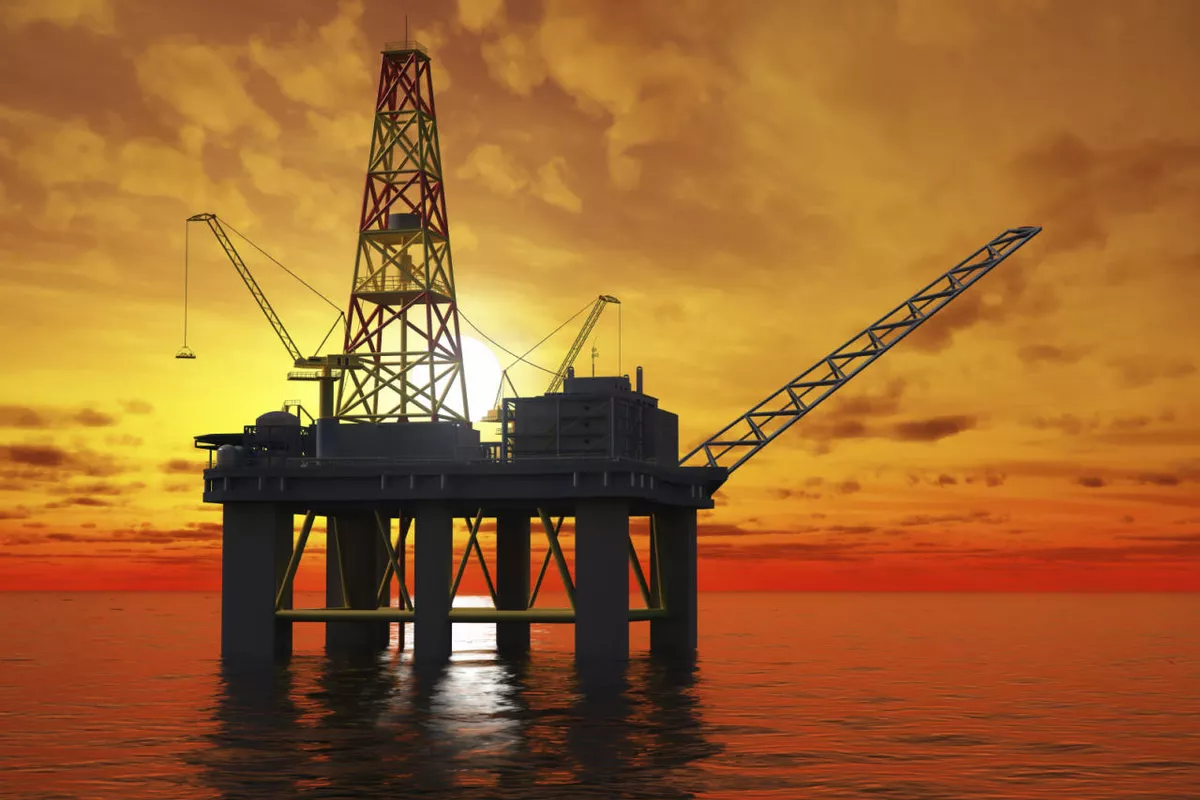
The State Oil Company of the Republic of Azerbaijan (SOCAR) has launched a new phase of offshore exploration in Azerbaijan’s sector of the Caspian Sea with detailed seabed studies at the promising Goshadash structure. The project marks a preparatory stage ahead of a large-scale seismic survey that will use advanced Ocean Bottom Node (OBN) technology, underscoring Azerbaijan’s commitment to expanding its hydrocarbon resource base and maintaining its role as a key energy supplier to regional and global markets.
The survey initiates a complex geophysical program to gather high-resolution data on the geological structure beneath the seabed. Before deploying OBN sensors, specialists will carefully study the seabed’s morphology and geology to determine the safest and most effective locations for the equipment. This phase involves detailed mapping of the seafloor, identifying potential obstacles, and evaluating geological stability in the targeted exploration area.
Such preparatory work is essential in offshore geophysics. The accuracy of future seismic surveys depends heavily on the quality of seabed mapping. SOCAR’s geophysicists aim to create a precise model of the seafloor environment so the OBN sensors can be positioned optimally, ensuring both maximum data accuracy and operational safety.
Understanding the Goshadash Structure
The Goshadash structure lies within Azerbaijan’s Caspian sector, near the Absheron Peninsula, an area historically known for rich hydrocarbon deposits. It forms part of the South Caspian Basin, one of the world’s most prolific oil and gas provinces. Over the decades, this basin has yielded several major energy projects that have shaped Azerbaijan’s economy and global energy profile.
Major fields in the region include Azeri-Chirag-Gunashli (ACG), the country’s largest oil complex, and the Shah Deniz gas field, which forms the backbone of the Southern Gas Corridor, delivering natural gas to Europe. The Absheron gas condensate field is currently being developed with international partners and is expected to boost Azerbaijan’s export capacity in coming years.
The proximity of Goshadash to these projects has attracted considerable interest. Geological studies suggest similar sedimentary formations extend across the South Caspian Basin, raising the likelihood of additional hydrocarbon discoveries. If confirmed through exploration drilling, Goshadash could become another key addition to Azerbaijan’s offshore resource portfolio.

Photo credit: SOCAR
The Role of Seabed Surveys
Before launching full seismic operations, SOCAR is conducting a thorough investigation of the seabed. Offshore exploration involves deploying sophisticated equipment directly on the ocean floor. Any irregularities, such as rock formations, ridges, unstable sediment, or man-made obstacles, could interfere with sensor placement or affect seismic data quality.
To mitigate these risks, specialists perform detailed hydrographic and geophysical surveys using multibeam echo sounders and side-scan sonar systems, generating highly detailed maps of the seabed. This data enables engineers to plan seismic surveys efficiently, improving data quality while reducing operational risks and costs.
To mitigate these risks, specialists conduct detailed hydrographic and geophysical surveys using modern technologies, including multibeam echo sounders and side-scan sonar systems. These tools produce highly detailed maps of the seabed, helping to identify features that could affect the deployment of OBN sensors.
The data collected at this stage enables engineers to plan the seismic survey with maximum efficiency. Accurate seabed mapping not only enhances the quality of seismic data but also reduces operational risks and lowers costs during later stages of exploration.
Ocean Bottom Node Technology
The upcoming seismic survey at Goshadash will use Ocean Bottom Node (OBN) technology, one of the most advanced and reliable methods for offshore seismic exploration. Unlike traditional surveys that rely on long cables towed behind vessels, OBN places autonomous recording devices directly on the seabed.
Each node is equipped with sensors that detect seismic waves generated by specialized sound sources. These waves travel through the seabed and reflect off underground geological formations. By analyzing the returning signals, geophysicists can produce detailed three-dimensional images of the subsurface.
OBN offers several advantages over conventional seismic techniques. Sensors positioned on the seabed capture seismic signals with greater clarity and less interference from water movement, resulting in higher-resolution data. This allows geologists to identify smaller and more complex hydrocarbon traps.
The technology is particularly effective in areas with complex geology, such as salt formations or deep sediment layers, common in the South Caspian Basin. As a result, OBN surveys are increasingly adopted by energy companies worldwide to improve exploration success rates.
International Cooperation in Offshore Surveys
The seabed survey at Goshadash is being carried out by SOCAR’s Geological and Geophysical Department in partnership with SOCAR Fugro, a joint venture specializing in marine geophysical and geotechnical services. Fugro is a globally recognized company with extensive experience in offshore surveys and subsea data acquisition.
The collaboration reflects SOCAR’s broader strategy of combining domestic expertise with international technological capabilities. By working with experienced global service providers, the company aims to ensure Caspian Sea exploration projects meet the highest technical and safety standards.
Partnerships like this have become standard in the offshore energy industry, where complex operations often require specialized equipment and know-how. For Azerbaijan, cooperation with international partners also supports the transfer of advanced technology and skills to the local workforce.
Previous offshore exploration efforts
SOCAR has conducted seabed and seismic surveys across multiple offshore structures in the Caspian Sea over the past decades. These efforts have been crucial in identifying new hydrocarbon resources and extending the life cycle of Azerbaijan’s energy sector.
A prominent example is the Absheron gas condensate field. Before drilling exploration wells that confirmed its reserves, extensive seismic surveys mapped the subsurface structure. The data allowed engineers to identify optimal drilling locations and estimate the field’s resource potential.
The Karabakh offshore structure has also drawn renewed attention. SOCAR and its partners have conducted modern geophysical surveys to reassess the area’s hydrocarbon potential using advanced imaging technologies.
Similarly, the Shafag-Asiman block, located in deeper Caspian waters, has been the focus of large-scale seismic campaigns. These surveys have helped geologists better understand the area’s geological complexity and prepare for future exploration drilling.
Seismic surveys are not limited to new projects. Mature fields are also regularly surveyed to improve reservoir management. By updating geological models, companies can identify additional hydrocarbon pockets that may have been overlooked in earlier development stages.
Strategic importance for Azerbaijan
The launch of exploration activities at Goshadash underscores Azerbaijan’s long-term strategy to maintain a strong position in the global energy market. While existing fields continue to produce significant volumes of oil and gas, the country recognizes the need to discover new reserves to sustain future production.
Hydrocarbon exports remain a cornerstone of Azerbaijan’s economy. Revenues from the oil and gas sector support national development programs, infrastructure projects, and economic diversification initiatives. Expanding the resource base through exploration is therefore essential for ensuring economic stability.
Azerbaijan’s role in international energy security has also grown in recent years. Through projects such as the Southern Gas Corridor, the country supplies natural gas to European markets seeking to diversify their energy sources. Additional discoveries could further strengthen Azerbaijan’s ability to meet rising demand.
In this context, exploration efforts like the Goshadash survey contribute not only to national economic interests but also to broader regional energy stability.
Technological Innovation in Exploration
The energy industry is undergoing rapid technological transformation, and SOCAR has increasingly incorporated modern digital tools into its exploration programs. Advanced data-processing algorithms, artificial intelligence, and high-performance computing are now used to analyze seismic data and generate detailed geological models.
The adoption of technologies such as OBN reflects a broader trend toward more precise and efficient exploration methods. High-resolution seismic imaging reduces uncertainty and increases the likelihood of successful discoveries, enabling companies to allocate resources more effectively.
Digital tools also allow engineers to simulate reservoir behavior before drilling begins. These simulations help design optimal development strategies while minimizing environmental impact.
By embracing technological innovation, SOCAR aims to stay competitive in a rapidly evolving global energy landscape.

Photo credit: SOCAR
Environmental Considerations
Offshore exploration activities are carried out under strict environmental regulations aimed at protecting marine ecosystems. Before operations begin, companies must assess potential impacts and implement measures to minimize disruption to marine life.
Seabed surveys themselves are generally low-impact. The equipment used to map and scan the ocean floor does not involve drilling or extraction, and the sound frequencies employed by modern sonar systems are carefully regulated.
SOCAR has emphasized its commitment to environmental responsibility across all offshore projects. The company works closely with regulatory authorities and international partners to ensure that exploration activities comply with both national laws and international environmental standards.
Looking Ahead
The seabed study at the Goshadash structure marks the first stage of a multi-phase exploration process. Once the survey is completed and the optimal locations for the OBN sensors are identified, the next phase will involve deploying the nodes and carrying out the full seismic acquisition program.
Data collected during the campaign will be processed and analyzed by geophysicists to identify potential hydrocarbon traps. If promising structures are found, exploratory drilling could follow in the coming years.
While the results of exploration cannot be predicted with certainty, the geological characteristics of the South Caspian Basin offer strong reasons for optimism. The region has consistently yielded major discoveries, and ongoing exploration continues to reveal new opportunities.
For Azerbaijan, initiatives like the Goshadash survey demonstrate that the Caspian Sea remains a vital frontier for energy development. As global energy demand evolves and new technologies reshape the industry, the country is positioning itself to remain a key player in the international energy market.
The launch of seabed surveys at Goshadash is therefore more than a technical operation - it represents a strategic investment in Azerbaijan’s future as a leading energy producer and a reliable partner in global energy supply.
Tural Heybatov