Delimitation and demarcation of the border is a harder challenge than it seems for Azerbaijan and Armenia. Base maps, Soviet-era exclaves and changing on-the-ground realities categorize the issues.
Image: ozodlik.org/Ernist Nurmatov
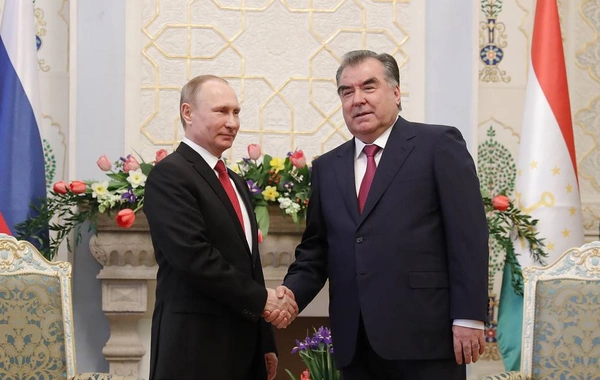
After a meeting in Brussels on May 22, 2022, the leaders of Azerbaijan and Armenia announced that they would be setting up border commissions to work towards the delimitation and then demarcation of their mutual frontiers. That meeting took place just three days later, on May 24. The process might seem a nonsensical waste of time for those unfamiliar with the issue – surely, a border is a border, right?
Sadly, it’s not that easy.
The problems fall into three main issues: different base maps, inconvenient Soviet exclaves and changing on-the-ground realities.
Base Maps
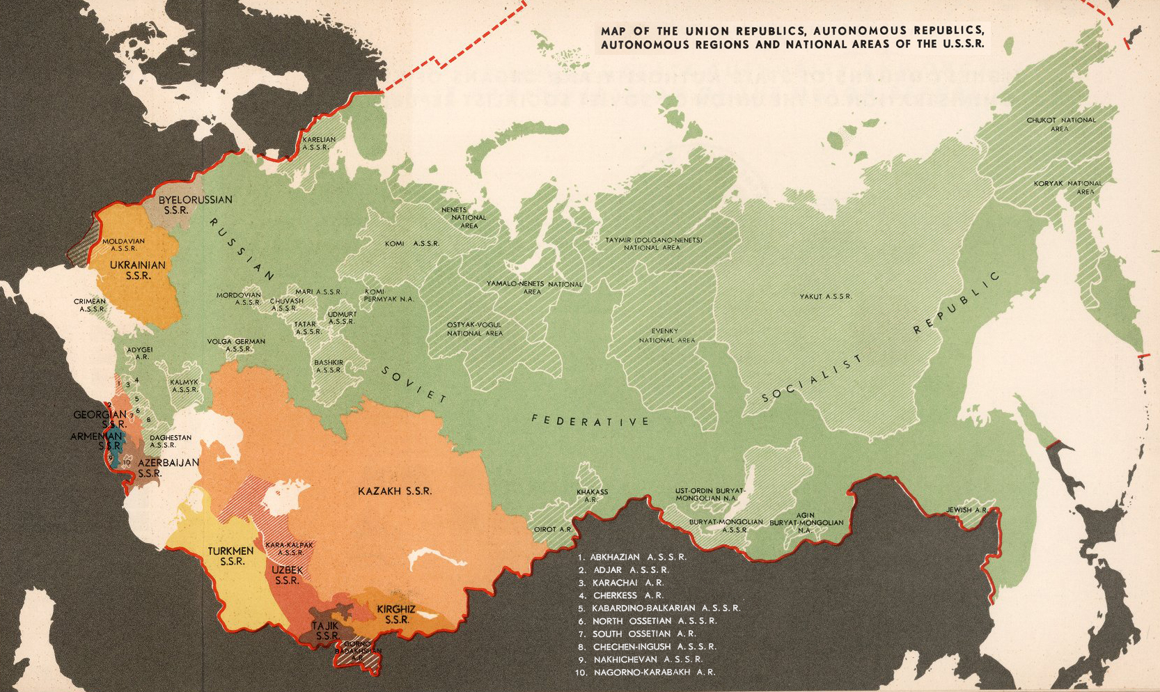
The most fundamental starting point for delimitation is agreeing on which map of the Azerbaijan-Armenia border should be used as its basis. Both sides essentially agree that early Soviet-era maps should be the starting point, but there are different versions and different scales, which sometimes leave ambiguities or arguments. Azerbaijan’s President Ilham Aliyev further added to the uncertainty when speaking at a conference in early May. He repeated a viewpoint that no single map could be considered definitive and that ‘
,’ reminding listeners that in the years directly after WWI, the border changed significantly as formerly Azerbaijani territory was awarded to Armenia.
Image: visualcapitalist.com
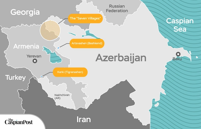
Exclaves
Whichever base map is settled upon, there is another lurking problem waiting in the wings. The USSR loved to create fiddly borders with disconnected exclaves of one republic dotted within another. Such cartographic craziness can be traced back to the idea of korenisatsiya ‘indigenization,’ gerrymandering borders to fit while ensuring that any breakdown of cooperation between republics would be potentially painful. The use of exclaves was most lavish in Central Asia. Still, the Soviet-era Caucasus had a handful of its own – little one- or two-village blobs of territory entirely surrounded by that of the other country.
Artsvashen (known to Azerbaijanis as Bashkand) is a large ruined Armenian village within the Gadabey region of Azerbaijan. Kerki is a single disconnected village just northwest of the Nakhchivan region but now inhabited by Armenians and claimed by Armenia, which calls the place Tigranashen. The most sensitive exclave issue is the so-called ‘seven villages’ of the Qazakh Region, all occupied by Armenia. These include two exclaves (Yukhari Askipara, and Barkhudarli/Sofulu) of Azerbaijani territory within Armenia, along with four other Azerbaijani villages (Ashaghı Askipara, Qizil Hacili, Seyid Ayrim/Baghanıs Ayrım and Kheyrimli) that were joined to the rest of the region but captured nonetheless by Armenians during the First Karabakh War.
From an outside perspective, it might seem an elegant idea to quietly accept the status quo and prevent the practical difficulties of recreating the fiddly exclaves as part of a strict return to the pre-war map. However, it would take considerable political courage to reformulate such an agreement, given the obvious desires of many long-term IDPs (internally displaced persons) to return to their villages of birth. And, as can be seen from Central Asia’s trouble-plagued examples like Vorukh and Sokh, re-instating such exclaves could be even more of a poisoned chalice than deciding to form an amicable and mutually beneficial solution.
Armenia’s Building Creep and Border Highway
For most of the 1990s, large parts of western Azerbaijan were occupied by Armenian forces and fell within the nominally independent, if internationally unrecognized republic that was known as Nagorno Karabakh. In reality, that entity was a de facto continuation of Armenia, which was so confident that their territorial gains would be permanent that building work often edged across what seemed then a purely nominal line into Azerbaijani territory. However, the 2020 Second Karabakh War suddenly meant that such careless land grabs would come back to bite.
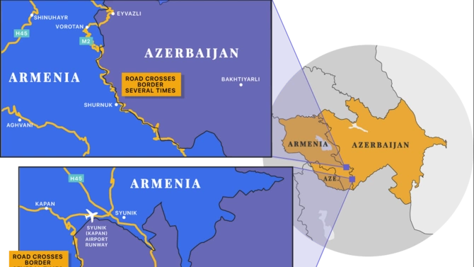
The M2 Highway
The most obvious problem comes from the routing of the M2 highway between Goris and Kapan, which criss-crosses the border in several places – some a few hundred metres, other longer stretches such as through the ruined Azerbaijani hamlet of Eyvzali. Part of the road problem dates back to Soviet engineers building without any interest in the borderline – at the time essentially nominal as both countries were firmly within the USSR. The installation of checkpoints on each of these international crossings since 2020 has raised the possibility of serious interruption in the use of the road if checks are enforced – impeding Armenia’s major trade route to Iran, as happened a couple of times in 2021.
Meanwhile, there’s the celebrated case of Shurnukh, a village on the M2 just within Armenia (though it had been home to ethnic Azerbaijanis until 1989 when they fled to other parts of Azerbaijan). Soviet maps from 1988 show the Armenia-Azerbaijan borderline cutting through the village along the main road. Since the 1990s, with the border essentially forgotten, Armenians who came to live in the village expanded the settlement with a dozen houses built on the ‘other’ side across the road. These have now reverted to Azerbaijani control.
Armenia has been busily building workarounds to prevent the M2 problem from becoming a long-term headache, while Azerbaijan is constructing a completely new 28.5km road to Eyvzali from Qubadli. However, that doesn’t negate the need for more explicit borders to ensure that international incidents are avoided in the future.

